Road Access Update
July and August 2026 – our access roads are currently suitable for 4×2 vehicles with good ground clearance, high-clearance vehicles, and all-wheel drive (AWD) vehicles.
Please note: Access is currently restricted for small, low-clearance vehicles, and combis, as the last 15km stretch to Cedar Falls/Basecamp remains rough following recent weather damage.
Important: Access is only available via the R332 from Willowmore. The road from Patensie remains closed and inaccessible to all vehicles.
If you’re unsure whether your vehicle is suitable, please feel free to contact us before you travel.
Go Baviaans
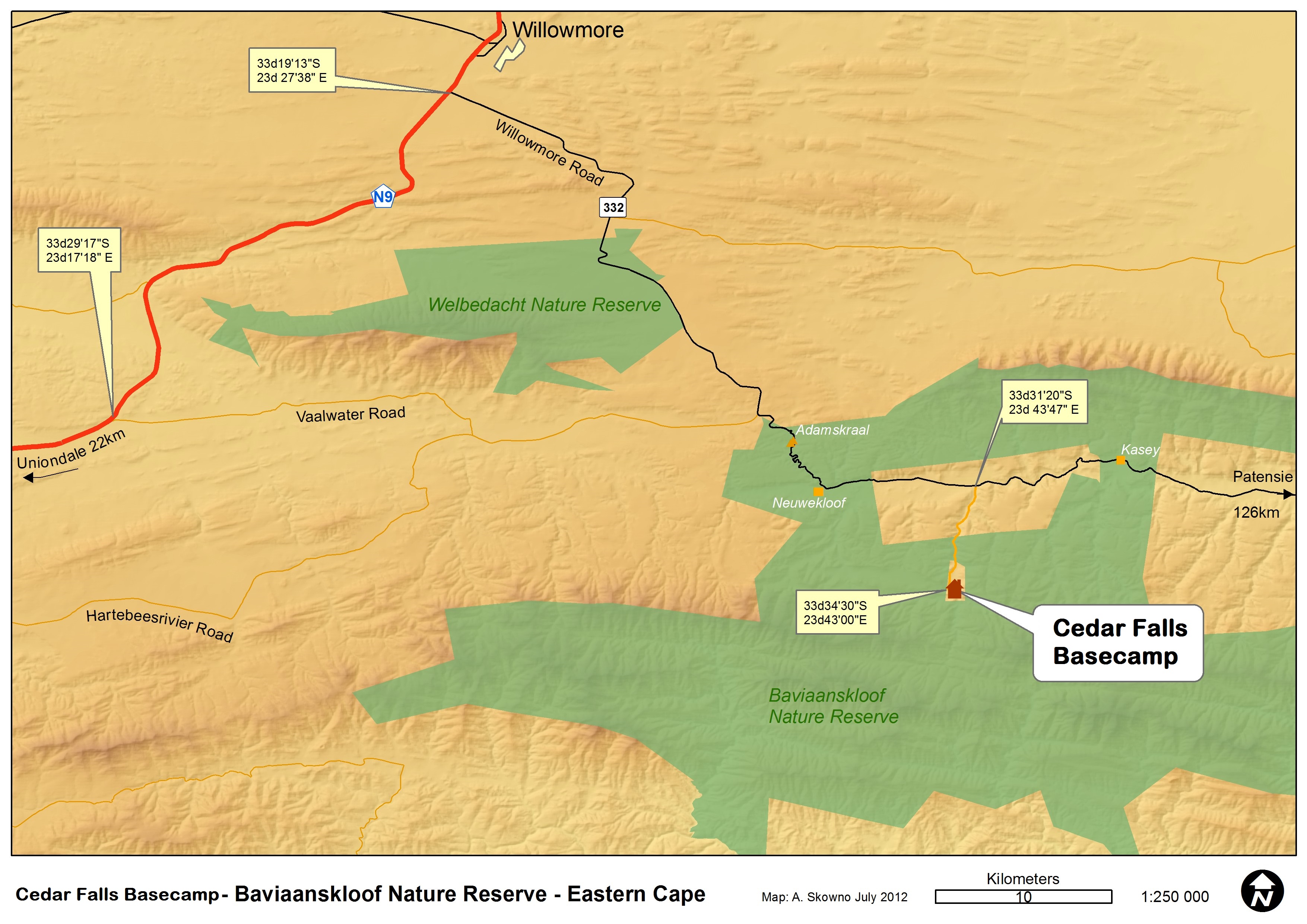
Directions to Cedar Falls Base Camp
Option A: Coming from Willowmore (1 hour travel time)
Head out from Willowmore on the N9 towards Uniondale. Three kilometers out of Willowmore, take the road on your left signposted “Baviaanskloof” https://theleopardtrail.co.za/baviaanskloof-turnoff . Keep going straight on this road for 31 km. At this point you will descend into the Nuwe Kloof Pass. From the bottom of the pass keep going on the road for another 7.4km, until you come to a road on your right hand side with the sign “Cedar Falls”. Take this road and keep going for 7 km. The road ends at Cedar Falls Basecamp.
Option B: Coming from Uniondale (1 hour 30 minutes travel time)
Head out of Uniondale on the N9 to Willowmore. After 53.7 km turn right into a dirt road, with a sign board saying “Baviaanskloof” https://theleopardtrail.co.za/baviaanskloof-turnoff . Keep going straight on this road for 31 km. At this point you will descend into the Nuwe Kloof Pass. From the bottom of the pass keep going on the road for another 7.4km, until you come to a road on your right hand side with the sign “Cedar Falls”. Take this road and keep going for 7 km. The road ends at Cedar Falls Basecamp.
Option C: Coming from Patensie through the Baviaanskloof ( Travel time about 6 hours – this route requires a 4×4 vehicle).
Important: Access is only available via the R332 from Willowmore. The road from Patensie remains closed and inaccessible to all vehicles.
Leaving Patensie, head into the Baviaanskloof World Heritage Site. Travel through the reserve, keeping on the main dirt road. Once you have left the main stone gate of the Wilderness Area on the Western end near Sandvlakte, travel for another 59 km until you come to the turnoff to Cedar Falls on the left hand side. The turn off is sign posted to “Cedar Falls”. Take this road and keep going for 7 km. The road ends at Cedar Falls Base Camp. Please note this road takes about 6 hours from Patensie to Cedar Falls so please make sure you have enough time.
GPS Co-ordinates: 33*34’31.28”S and 23*42’57.33”E